Geographic Information System Software
Powerful Mapping with Geographic Information System Software
What is GIS Software?
Geographic Information Systems (GIS) are powerful digital tools used to capture, manage, analyze, and visualize location-based data. At their core, GIS connects maps, data, and technology to help users better understand the world around them.
GIS software solutions integrates multiple components such as maps, data layers, analysis tools, software, and satellite imagery. Spatial Analytics Software enables users to perform spatial analysis, combine different data layers, and uncover patterns, relationships, and trends tied to specific locations.
Modern GIS software solutions is widely used through applications and software platforms, supporting a variety of careers across industries. From urban planning and environmental monitoring to business operations and public safety, GIS helps organizations make smarter decisions, improve efficiency, and gain valuable geographic insights.
Modern GIS-powered safety compliance management software helps businesses, governments, and industries understand location-based patterns, relationships, and risks. By leveraging advanced GIS tools and map data solutions, organizations can strengthen compliance, enhance safety management, improve infrastructure monitoring, and boost operational efficiency.
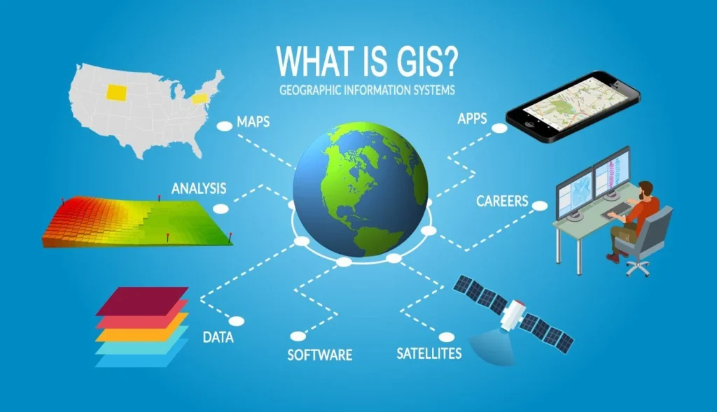
Components of GIS Software
Geographic Information System software is built on a set of interconnected components that work together to capture, manage, analyze, and visualize spatial data. As shown in the image, a modern GIS platform integrates the following key elements:
Maps
Maps are the core output of any geographic information system software. They provide a visual representation of spatial data, helping users understand locations, distributions, and geographic patterns.
Data
GIS relies on multiple layers of GIS data, including demographic, environmental, and infrastructure information. These layered datasets form the foundation for accurate insights within a GIS platform.
Analysis
GIS analytics software enables advanced spatial analysis, allowing users to identify patterns, relationships, and trends. This component transforms raw data into meaningful, actionable insights.
Software
The GIS platform itself provides the tools and interface needed to manage data, run analyses, and create visualizations. It connects all components into a single, functional system.
Satellites
Satellite technology supplies real-time and high-resolution geographic data, supporting mapping, monitoring, and environmental analysis within geographic information system software.
Apps
Modern GIS platforms extend functionality through mobile and web applications, making GIS data accessible anytime and anywhere for real-time decision-making.
Careers
The growing use of GIS analytics software has created diverse career opportunities across industries such as urban planning, environmental science, logistics, and public safety.
Together, these components make geographic information system software a powerful solution for understanding and leveraging location-based data.
Features of Geographic Information System Software
Geographic Information System Software offers a variety of features designed to manage and analyze spatial information effectively. Some key features include:
- Interactive GIS mapping software that allow users to create and customize geographic maps
- Advanced GIS Analysis Software for identifying patterns and trends in spatial data
- GIS Softwares for organizing and processing large geographic datasets
- Geographic Software for collecting and accessing field data in real time
Our Geographic Information System Software Expertise
At WorkAware, we provide best GIS software solutions designed to help organizations turn geographic data into actionable insights. As a trusted geospatial software solution, WorkAware delivers innovative GIS mappoint software that support safety management, infrastructure monitoring, and data-driven decision-making.
1- Mapping and Visualization
WorkAware’s GIS software transforms complex spatial data into clear, interactive maps. It helps organizations visualize assets and monitor locations in real time through GIS asset management, enabling better tracking, analysis, and operational visibility.
2- Spatial Analysis
Our GIS analysis software and spatial analytics software identifies patterns and relationships in geographic data. It enables informed decision-making, risk assessment, and optimized planning.
3- Location Intelligence
WorkAware delivers operations management software powered by GIS intelligence, transforming location data into actionable insights. Businesses can optimize resource allocation and streamline strategic operations with greater efficiency.
4- 3D Visualization Software
Our 3D visualization tools allow immersive exploration of geographic data. Users can analyze terrain, infrastructure, and spatial relationships in a realistic environment.
Benefits of Using GIS Software
Implementing the best GIS software provides several advantages for organizations across industries.
- Improved Decision-Making through accurate geographic insights
- Enhanced Operational Efficiency using advanced GIS tools
- Better Data Visualization with interactive GIS mapping programs capabilities
- Scalable GIS Solutions that grow with business needs
- Real-Time Field Data Collection through mobile GIS software
Many organizations partner with experienced geographic services companies to implement advanced GIS solutions that improve planning, safety management, logistics, and environmental monitoring.
Types of GIS Software
The GIS software industry provides a broad range of solutions, including both commercial and open-source products available in desktop, server, and cloud-based platforms.
1- Commercial GIS Software
Commercial software GIS is developed by established GIS software companies. It offers enterprise-grade tools, technical support, and advanced analytics for large-scale projects.
2- Open-Source GIS Software
Open-source GIS platforms provide flexible and cost-effective geographic software solutions. Users can customize features and integrate various GIS tools for specific project needs.
3- Server GIS
Server GIS allows organizations to store, manage, and share spatial data across networks. It supports collaboration and centralized access to Geographic Information System Solutions.
4- Cloud-Based GIS Platforms
Cloud-based GIS platforms provide scalable Geographic Information System Software Solutions accessible from anywhere. They enable real-time data sharing, collaboration, and integration with enterprise systems.
FAQs
What is GIS software, and what does it do?
GIS software, or Geographic Information System GIS software, is a type of GIS software used to capture, store, analyze, and visualize geographic data. It helps organizations transform location-based information into actionable insights through maps, dashboards, and GIS analytics software. Businesses, governments, and GIS services companies use GIS to improve planning, asset management, safety monitoring, and decision-making.
What are some common features of GIS software?
Most GIS software solutions include features such as interactive mapping, spatial data analysis, data visualization, and location intelligence tools. Many platforms also include mobile geographic software for field data collection, GIS grid software for managing large datasets, and advanced GIS analysis software for identifying patterns and trends in geographic information.
How can AI be used to improve the accuracy of GIS data?
Artificial intelligence can enhance GIS solutions by automatically detecting errors, filling missing data, and improving the quality of spatial datasets. AI-powered GIS intelligence software can analyze satellite imagery, sensor data, and geographic patterns to produce more precise and reliable GIS map data solutions.
Can AI be used to automate the process of creating maps in GIS?
Yes, AI can automate many mapping tasks within a GIS platform. AI algorithms can classify satellite images, detect geographic features, and automatically generate maps. This helps GIS software companies deliver faster and more accurate geographic software solutions while reducing manual work.
How can AI be used to analyze patterns in geospatial data?
AI enhances geospatial analytics software by identifying patterns and relationships within large spatial datasets. Machine learning models can analyze geographic trends, detect anomalies, and uncover insights that might be difficult to identify manually. This helps organizations make better decisions using advanced GIS tools and GIS analysis software.
Can AI be used to predict future environmental changes based on GIS data?
Yes, AI combined with GIS intelligence software can analyze historical geographic data to predict future environmental changes. These GIS solutions can forecast climate patterns, monitor deforestation, and assess natural disaster risks. Many GIS services companies use AI-powered GIS platforms to support environmental planning and sustainability initiatives.
Take Care of Clients with a Comprehensive GIS Software Platform
Get in touch with us, and we will deliver a personalized demonstration of our software features including; People and Asset Management, Digital Forms, Tracking, Journey Management, Geographic Information System Software, and more, with the option of multiple test user accounts in our live demo environment. A member of our team will contact you shortly.
Talk to our 24/7 Customer Service teams:
US Office: 312-761-5423
Canada Office: 647-249-1622